


Precinct No. 8273, Washoe County, Nevada
About
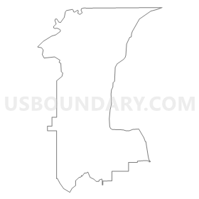
Outline
Summary
| Unique Area Identifier | 615532 |
| Name | Precinct No. 8273 |
| County | Washoe County |
| State | Nevada |
| Area (square miles) | 37.09 |
| Land Area (square miles) | 37.07 |
| Water Area (square miles) | 0.02 |
| % of Land Area | 99.93 |
| % of Water Area | 0.07 |
| Latitude of the Internal Point | 39.25832300 |
| Longtitude of the Internal Point | -119.85992910 |
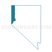
Maps


Graphs
Select a template below for downloading or customizing gragh for Precinct No. 8273, Washoe County, Nevada


Neighbors
Neighoring Voting District (by Name) Neighboring Voting District on the Map
- Precinct 107, Carson City, NV
- Precinct No. 8109, Washoe County, NV
- Precinct No. 8111, Washoe County, NV
- Precinct No. 8112, Washoe County, NV
- Precinct No. 8219, Washoe County, NV
- Precinct No. 8220, Washoe County, NV
- Precinct No. 8221, Washoe County, NV
- Precinct No. 8222, Washoe County, NV
- Precinct No. 8236, Washoe County, NV
- Precinct No. 8264, Washoe County, NV
- Precinct No. 9105, Washoe County, NV
- Precinct No. 9106, Washoe County, NV
- Precinct No. 9111, Washoe County, NV
- Precinct No. 9242, Washoe County, NV
Top 10 Neighboring County Subdivision (by Population) Neighboring County Subdivision on the Map
- Reno Southwest CCD, Washoe County, NV (57,544)
- Carson City CCD, Carson City, NV (55,274)
- Washoe Valley CCD, Washoe County, NV (12,741)
- Incline Village CCD, Washoe County, NV (9,087)
Top 10 Neighboring Place (by Population) Neighboring Place on the Map
Top 10 Neighboring Unified School District (by Population) Neighboring Unified School District on the Map
Top 10 Neighboring State Legislative District Lower Chamber (by Population) Neighboring State Legislative District Lower Chamber on the Map
- Assembly District 26, NV (69,333)
- Assembly District 39, NV (53,415)
- Assembly District 40, NV (49,877)
Top 10 Neighboring State Legislative District Upper Chamber (by Population) Neighboring State Legislative District Upper Chamber on the Map
- Washoe County Senatorial District 3, NV (115,167)
- Washoe County Senatorial District 4, NV (110,453)
- Capital Senatorial District, NV (102,155)
Top 10 Neighboring 111th Congressional District (by Population) Neighboring 111th Congressional District on the Map
Top 10 Neighboring Census Tract (by Population) Neighboring Census Tract on the Map
- Census Tract 32.02, Washoe County, NV (5,670)
- Census Tract 32.03, Washoe County, NV (4,549)
- Census Tract 4, Carson City, NV (3,811)
- Census Tract 3, Carson City, NV (3,806)
- Census Tract 33.09, Washoe County, NV (2,546)
- Census Tract 32.04, Washoe County, NV (2,522)
- Census Tract 33.08, Washoe County, NV (2,333)
- Census Tract 9803, Washoe County, NV (8)
Top 10 Neighboring 5-Digit ZIP Code Tabulation Area (by Population) Neighboring 5-Digit ZIP Code Tabulation Area on the Map
- 89521, NV (25,716)
- 89511, NV (25,011)
- 89706, NV (19,510)
- 89703, NV (9,714)
- 89451, NV (8,930)
- 89704, NV (4,290)